Since 1927, Iraq has committed to conducting a population census every ten years to monitor population growth. The last official census, made by the Ministry of Planning's Central Organization for Statistics (COSIT) in 1997, covered fifteen provinces, except for Kurdistan region, and counted a population of 19,184,543 people. The total estimated population of Iraq at that time was around 21,000,000 people.
In 2021, the COSIT reported an estimated population of 41,190,658 people, 51% or 20,810,479 of which were males, while 49% or 20,380,179 were females. The report also demonstrated that the inhabitants of urban areas in Iraq amounted to 28,779,201 people, accounting for 69.9% of the country's population. On the other hand, residents of rural regions accounted for 30.1% of the total population, with 12,411,457 people.
The report also revealed that Baghdad was the most populated governorate, with an estimated count of 8,780,422 people—representing 21.3% of the total population. While Al-Muthanna was the least populated, with about 880 thousand people, making up for only 2.1%.


Projections from 2015 to 2030 indicate that if Iraq's population growth rate continues in this manner, it is forecasted to exceed 50,000,000 people in 2030.

Baghdad:
The country’s national and provincial capital covers an area of 5,169 square kilometers, encompassing 32 administrative units (sub-district) that comprise ten districts. Baghdad's population growth rate of 2.1% accommodates 8,780,422 people, according to the Multiple Indicator Cluster Survey (MICS 6). The capital’s urban region is home to 7,287,750 people, accounting for 83% of the province's population. Whereas rural areas house 1,492,692 people, representing only 17%.
Globally, building and zoning codes shape the urban planning of cities. The absence of these laws and their enforcement resulted in haphazard changes in land use, which in turn caused the emergence of slums. The following are some of the main rules, legislations, and zoning determinants that can be used to identify the type and size of residential zoning violations.

Building Codes and Legislation
Zoning Codes for Residential Areas (Individual Residence)
- The area of the zoned individual residence plot should not be less than 200 square meters, with proper dimensions and a width not less than 8 meters.
- The required setback from the side of the main road for construction depends on the land area. A parcel of land with an area of 120-240 square meters requires a setback of 1.5 meters, while the larger one measuring 241-600 square meters requires a setback of 2.5 meters, and the expansive plots of 600-800 square meters require a setback of 4 meters.
- Residential houses should not be higher than 9 meters from the sidewalk level, which means the house can have up to three floors within this height limit.
Planning Laws and Legislations in Force in Iraq
- The Master City Plan Law for Baghdad No. 156 of 1972: The law stipulates that it is illegal to use, alter the use, or build on land without a permit from the Mayoralty of Baghdad and that such a permit will only be granted if the proposed use is in line with the city's master plan.
- According to Resolution No. 940 of 1987, residential plots must have a minimum area of 200 square meters in the province center, 250 square meters in the sub-district center, and 300 square meters in the district center.
Fines
- Resolution No. 154 of 2001: This law states that encroachment must be removed, and the Ministry and other competent entities are responsible for that. It mandates that encroachment be removed at the violator’s expense within 15 days of being notified. Another way this could be done is by making the encroacher bear the costs of rectifying the encroachment and compensate for any damages caused by it within 10 days. If they fail to comply, they will be detained until the amount is paid. According to this law, transgressors may face imprisonment in some cases.
Types of Violations
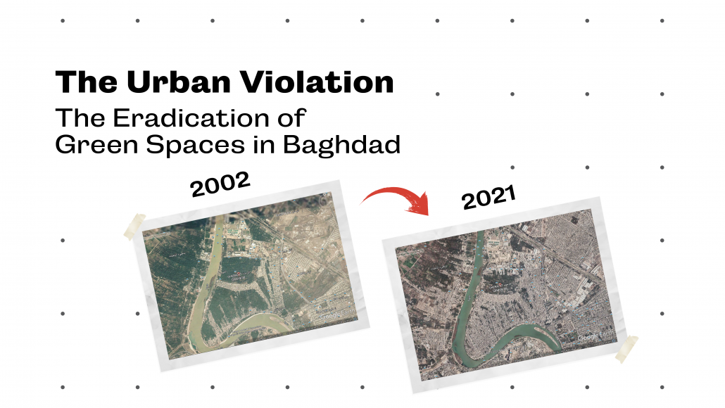
- Encroaching land uses and changing the land use type for another purpose other than its origin is one of the most common transgressions making up 40% of all violations. Numerous residential complexes and areas have been constructed without obtaining a building permit due to not being recognized by municipalities. In localities such as ِAl-Gherai'at, Al-Taji, Dora orchards, Al-Buaytha, and many others, agricultural lands have been transformed into residential without legally changing their type.

Google Earth (2002) Dora Orchards, Baghdad, Iraq 33°15'32.10"N, 44°24’47.01"E, elevation 34m.

Google Earth (2021) Dora Orchards, Baghdad, Iraq 33°16'14.43"N, 44°21’24.55"E, elevation 35m.
The agricultural lands have been transformed into residential without legally changing their type

Google Earth (2002) Gherai’at, Baghdad, Iraq 33°24'22.86"N, 44°20’38.98"E, elevation 37m.

Google Earth (2021) Gherai’at, Baghdad, Iraq 33°25'17.58"N, 44°18’40.46"E, elevation 35m.
The agricultural lands have been transformed into residential without legally changing their type

Google Earth (2002) Bo’aitha, Baghdad, Iraq 33°14'00.01"N, 44°25’42.54"E, elevation 31m.

Google Earth (2021) Bo’aitha, Baghdad, Iraq 33°13'54.23"N, 44°25’40.69"E, elevation 31m.
The agricultural lands have been transformed into residential without legally changing their type
Another widespread breach and non-compliance with the codes of sorting and building is dividing the residential plot or house into lots with very small areas of less than 100 square meters, and in some cases even smaller than 50 square meters, and then selling them or building on them without official permission. As well as building three floors with an external staircase, intending to rent or sell the property or use it for a family member’s residence. These cases account for about 30% of all violations.

Google Earth (2002) Yarmouk, Baghdad, Iraq 33°17'40.82"N, 44°19’42.08"E, elevation 34m.

Google Earth (2021) Yarmouk, Baghdad, Iraq 33°17'46.42"N, 44°19’41.47"E, elevation 34m.
The residential plots have been divided into lots with an area of less than 100 square meters
Violations of building regulations, such as crossing street lines, are ubiquitous. In some areas, municipal planning and the Ministry of Planning require a green setback space in front of houses. Although this area is attached to the house and could be used as an outdoor garden, it is state property, not part of the privately owned land. Unfortunately, this green space is currently being overtaken and built on.
Other common violations include non-compliance with front and side setbacks, encroachment on sidewalks, building heights exceeding legal limits, and surpassing the permitted number of floors and percentage of construction. In addition, buildings are used for several purposes or constructed in a manner that does not conform to the land’s original use. An example of this is opening small shops from houses or adding commercial floors. All these violations have resulted in the illegal conversion of many areas that are zoned out as residential into commercial areas.

Google Earth (2003) Basra Street, Al-Khadraa, Baghdad, Iraq 33°19'33.89"N, 44°17’47.51"E, elevation 34m.

Google Earth (2021) Basra Street, Al-Khadraa, Baghdad, Iraq 33°19'29.05"N, 44°17’51.57"E, elevation 34m.
The green setback space in front of houses has been overtaken and built on.
Impacts of Violations on Urban and Environmental Planning
The elimination of green spaces surrounding houses and the transformation of well-designed residential areas into overcrowded, chaotically arranged structures have negative environmental and health impacts. Inefficient setbacks and random mixing of land uses in the same area are the main causes of these negative impacts. For example, an old house may be demolished and rebuilt into a residential building with more than three apartments or a commercial building with shops on the ground floor and various businesses on the upper floors, such as offices, companies, or clinics. These factors contribute to a decline in the quality of living conditions and can lead to adverse health outcomes. On the other hand, slums are being exploited by factories and repair shops; a living example of this would be Al-Talbieh Street, 7 Nissan Street in Al-Amel district, and Haddadin in Ur district, which has been completely transformed into a hub for car repairs and tire sales. A huge part of Al-Bayaa area has been converted into a vast car repair center that is stratified into three industrial streets. Al-Basra Street in Baghdad is another example, where building material stores now line up next to each other along the road.
The illegal exploitation and alteration of the character and use of residential areas to commercial ones have led to a surge in the prices of both selling and renting houses, affecting the dwellings in the adjacent streets to match the price difference. This type of violation is among the reasons prompting communities to seek out small plots of land that match their financial means, allowing them to reside in their desired areas while remaining close to their families. This, in turn, has led to a rise in demand for small residential land as it is more budget-suitable, which has further driven up prices and increased population density within governorates.
Suggestions
The issuance of a collective Title Deed of property less than 200 square meters should be ceased, and the ownership of such property should be limited to only one person. In cases where estates are inherently distributed to multiple owners, heirs should be given undivided shares and required to pledge not to divide the land or house they inherited.
An end must be put to the unauthorized random building movement of residential units on agricultural lands, where residential plots are divided imprudently without adhering to the city's planning, codes, and regulations. Furthermore, the state should build new residential areas and allocate land for this purpose. The land should be distributed appropriately and zoned into designated areas, with necessary infrastructure and social facilities provided.
New commercial areas must be created and spread out on the city outskirts for investment and to promote the expansion of the city center. To minimize the loss of urban green space and its adverse environmental and public health effects.
Extending vertical construction can be adopted as a solution to the population increase and building density. However, it is essential to consider the area and population density that will dwell in these complexes in relation to their ground area. Furthermore, new cities that are integrated with basic activities and services should be established.
On the regulatory side, new building codes that align with population growth and urban sustainability must be implemented, and the garden annexed to houses should comprise at least 10% of the plot area. Immediate steps must be taken to abolish any violations that distort the urban appearance. This can be done by enforcing procedures and legislation related to planning violations and imposing the necessary penalties. Additionally, in case of ownership transfer, a mandatory inspection should be conducted for the buildings before the transfer of the Title Deed to ensure that the actual condition of the building matches the government approvals.
